
Volcano Erupts In Southwestern Iceland Nearby Residents Evacuated
Southwestern Iceland Volcano Erupts: Thousands Evacuated as Lava Flows Threaten Grindavík
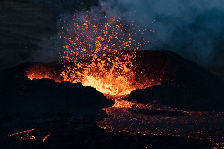
A significant volcanic eruption commenced in southwestern Iceland on Monday, forcing the immediate evacuation of approximately 1200 residents from the coastal town of Grindavík. The Reykjanes Peninsula, a region already experiencing intense seismic activity for weeks, has once again become the epicenter of a dramatic geological event. The eruption, characterized by a powerful fissure opening and spewing molten rock, has triggered widespread concern and a swift emergency response from Icelandic authorities. The lava flow, moving with considerable speed, poses an imminent threat to the infrastructure and the very existence of Grindavík, a town of roughly 3,700 people. This event marks the latest in a series of volcanic unrest that has captivated and concerned scientists and the public alike in this geologically active part of the North Atlantic. The rapid onset of the eruption and the proximity of the lava to populated areas have necessitated a large-scale and urgent evacuation operation, underscoring the dynamic and often unpredictable nature of Iceland’s volcanic landscape.
The eruption began shortly after a period of heightened seismic activity, a precursor that volcanologists had been closely monitoring. Small earthquakes had been intermittently shaking the Reykjanes Peninsula for several weeks, indicating a buildup of magma beneath the surface. The seismic swarm intensified significantly in the hours leading up to the eruption, with thousands of tremors recorded. This intensified seismic activity, coupled with ground deformation detected by GPS measurements, strongly suggested that a volcanic intrusion was underway and nearing the surface. Authorities, anticipating a potential eruption, had already elevated the alert level and were in a state of readiness. The eruption manifested as a fissure, a linear crack in the Earth’s crust, that rapidly opened and began to eject incandescent lava. The visible plume of smoke and ash, though not immediately classified as a major ash cloud threatening air travel, was a stark visual confirmation of the eruption’s commencement. The precise location of the fissure, reportedly just a few kilometers north of Grindavík, heightened the sense of urgency.
The decision to evacuate Grindavík was made swiftly and decisively by the Icelandic Directorate of Emergency Management and the National Police Commissioner. The primary concern was the safety of the residents, given the direct path of the approaching lava flow. Evacuation orders were issued to all inhabitants, with efforts focused on ensuring a rapid and orderly departure from the town. Emergency services, including police and civil defense personnel, were deployed to assist with the evacuation, guiding residents to designated safe zones and assembly points. The speed of the lava flow was a critical factor in the evacuation timeline. While the exact rate can vary, the molten rock can travel at speeds that make waiting a perilous choice. Roads leading out of Grindavík were quickly congested as residents, many with only minutes to pack essential belongings, sought safety. The evacuation was a significant logistical challenge, involving the relocation of thousands of individuals, many of whom were experiencing this type of crisis for the first time. The Icelandic government has pledged full support to the evacuated residents, including providing temporary accommodation and essential services.
The geological context of the Reykjanes Peninsula is crucial to understanding this ongoing volcanic activity. The peninsula sits atop the Mid-Atlantic Ridge, a divergent tectonic plate boundary where the North American and Eurasian plates are slowly pulling apart. This process creates a zone of intense volcanic and seismic activity. The recent series of eruptions on Reykjanes, starting in March 2021, signifies a renewed period of volcanic unrest in this region after centuries of relative dormancy. Scientists believe that the current magmatic system is characterized by a series of interconnected magma chambers and conduits that can become active in succession. The specific eruption on Monday is believed to be part of this broader Reykjanes volcanic system, potentially linked to previous eruptive events at nearby locations like Fagradalsfjall. Geologists are diligently monitoring the subsurface processes, analyzing seismic data, gas emissions, and ground deformation to better understand the extent and future behavior of this volcanic system.
The immediate impact of the eruption on Grindavík is devastating. The town is situated in a volcanic hazard zone, and the current lava flow is directly threatening its structures. The molten rock, flowing from the newly opened fissure, has the potential to engulf buildings, roads, and critical infrastructure. Power lines, water supply, and telecommunications networks are all at risk. The heat from the lava is immense, and its destructive power is absolute, consuming everything in its path. The economic and social consequences for Grindavík are profound. Many residents have lost their homes and their livelihoods. The long-term viability of the town will depend on the duration and intensity of the eruption, as well as the potential for future volcanic activity in the area. The psychological toll on the evacuated population is also a significant concern, as they face uncertainty and the prospect of displacement.
The response from Icelandic authorities has been swift and multifaceted. The Icelandic Meteorological Office (IMO) is at the forefront of monitoring the eruption, providing real-time data on seismic activity, gas emissions, and lava flow. The National Commissioner of Police has coordinated the evacuation efforts, working closely with local police departments and civil defense organizations. The Icelandic Coast Guard has been on standby, and the Directorate of Health is ensuring that medical services are available. The Icelandic Road and Coastal Administration is assessing the impact on transportation infrastructure and working to maintain alternative routes for emergency services and displaced residents. The government has activated its emergency management agency and is coordinating international assistance if needed, although Iceland possesses a highly developed and experienced civil defense system. Scientists from the University of Iceland and other research institutions are actively involved in studying the eruption, providing crucial information to inform decision-making.
Looking ahead, the outlook for Grindavík and the Reykjanes Peninsula remains uncertain. The duration of the eruption is impossible to predict with certainty. Volcanic eruptions can last for days, weeks, or even months. The behavior of the lava flow, its speed and direction, can also change. Scientists will continue to monitor the situation closely, using advanced technology to track the magma movement and predict potential future eruptive sites. The long-term implications for the region include the possibility of repeated eruptions, requiring ongoing preparedness and adaptation. The Icelandic government faces the challenge of rebuilding and potentially relocating communities if the risk of future eruptions is deemed too high. The experience of this eruption underscores the need for continuous investment in scientific research, disaster preparedness, and resilient infrastructure in volcanically active areas. The global scientific community will undoubtedly be observing this event closely, learning valuable lessons from Iceland’s response to this powerful display of nature’s force. The potential for future eruptions on the Reykjanes Peninsula remains a significant concern, and ongoing monitoring and research are paramount.
